|
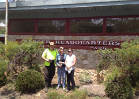
Where it all began The Timberleys' adventures began in Skippy Park which is in Waratah Park at Duffy's Forest. It was so named after the TV series which featured Skippy the bush kangaroo. Sadly, when the park was closed to the public because the RSPCA decided that the animals there were being neglected, the grounds soon became run down. I recently visited the park and met some very dedicated volunteers, lead by Jenny Harris from the Duffy's Forest Residents Association, who have undertaken the mammoth task of cleaning up the park on regular weekends. I also met Peter Staff who is passionate about making sure the park looks the best it can before it is handed over to the Aboriginal Lands Council in August 2014. He told me that some of the volunteers come from as far away as Newcastle!  Margi Law visits Skippy Park in Waratah Park, Duffy's Forest It would be wonderful to see the park opened up to the public once again. For information or offers to help in the clean up, contact Peter Staff on 9487 1471. Best wishes, Margi Law
|
|
Location and boundaries The Pittwater Council area is located on Sydney's northern beaches - about 26 kilometres from the Sydney GPO, being one of the bodies of water that separate greater Metropolitan Sydney from the Central Coast. The area is bounded by Broken Bay in the north, the Tasman Sea in the east, the Narrabeen Lakes and Deep Creek in the south, and the Warringah Council area in the south and west. Name origin The Pittwater Council area derives its name from the body of water so named by Captain Arthur Phillip in 1788. This includes the eastern reaches of the Hawkesbury River and Broken Bay. It was named after William Pitt, the Younger, Prime Minister of Britain in the late 18th and early 19th century. Settlement history The area was explored in 1788 by Captain Arthur Phillip. European settlement in the Pittwater Council area dates from 1796, after Governor Hunter surveyed Broken Bay. Development was slow, due largely to the area being relatively isolated and access being only by ship. Land grants occurred from 1810, with land used mainly for timber-getting and farming. Some growth occurred in the 1880s, spurred by improved access. Land continued to be used mainly for farming, grazing and orcharding, with some fishing, boat building and timber-cutting industries. The Pittwater Council area became a popular holiday destination, with many guesthouses and holiday homes built in the early 1900s and the interwar period. Significant residential development occurred from the 1950s, aided by the construction of bridges and roads. Much growth took place in the 1960s and 1970s. The population increased slightly from the early 1990s, rising from 49,500 in 1991 to nearly 56,000 in 2011*. |
|
|
|
Major features Major features of the area include Ku-ring-gai Chase National Park, Pittwater (including Broken Bay and the Hawkesbury River), Narrabeen Lakes, Scotland Island, several beautiful beaches, Mona Vale Hospital, Centro Warriewood Shopping Centre, Bungan Castle, Coastal Environment Centre, The Bible Garden, Barrenjoey Lighthouse and various lookouts, marinas, wharves and rockpools. Indigenous background The original inhabitants of the Pittwater Council area were the Aboriginal people now known collectively as the Guringai. Included areas The Pittwater Council area includes the suburbs and localities of Avalon, Bayview, Bilgola, Church Point, Coasters Retreat, Elanora Heights, Elvina Bay, Great Mackerel Beach, Ingleside (part), Ku-ring-gai Chase (part), Mona Vale, Morning Bay, Newport, North Narrabeen, Palm Beach, Scotland Island, Warriewood and Whale Beach. The three largest ancestries in Pittwater Council area are English, Australian, and Irish. Pittwater is a semi-mature tide dominated drowned valley estuary, located about 40 kilometres (25 mi) north of the Sydney central business district,New South Wales, Australia; being one of the bodies of water that separate greater Metropolitan Sydney from the Central Coast. The land adjacent to the Pittwater was occupied for many thousands of years by the Kuringgai Aboriginal peoples. They used the river as an important source of food and a place for trade. Pittwater was named Pitt Water in 1788 in honour of William Pitt the Younger, then Prime Minister of England.
|

